At Grid Fly, we deliver high-accuracy aerial data using RTK-enabled flights and L2 LiDAR, producing point clouds, orthomosaics, and 3D models aligned to your project coordinate system and control.
Our services are built to support surveyors, engineers, and project managers—filling the gap between field work and deliverables with fast, reliable site data for planning, analysis, volumetrics, and progress tracking.
Aligned, high-accuracy site data—delivered fast.
Accurate Mapping—Built for Engineering & Survey Workflows
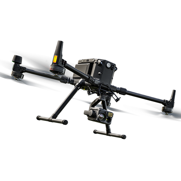
We capture high-accuracy geospatial data using the DJI Matrice 350 RTK with L2 LiDAR, supported by MnCORS GNSS corrections. When needed, we establish or tie into existing ground control using an Emlid RS3 receiver—delivering consistent, repeatable data with typical accuracy within 1–3 cm.
We deliver orthomosaics, point clouds, and surface models formatted for direct use in Civil 3D, Trimble, and GIS platforms. All outputs are clean, clearly labeled, and structured for immediate integration into your workflow
Orthomosaic imagery (GeoTIFF or JPEG)
3D point cloud (LAS/LAZ)
Digital surface models (TIFF)
Contours (DXF, SHP)
GCP/checkpoint CSVs with site-local coordinates
Accuracy reports with residuals, when checkpoints are used
Data That Drives Smarter Decisions
We don’t just provide visuals—we deliver decision-ready data. Our drone maps and models are built with spatial accuracy in mind, tailored to support tasks like surveying, volumetric analysis, development planning, and infrastructure inspections.
By capturing site conditions from the air, we help your crews stay focused on what they do best—without pulling them away for data collection. Whether you’re monitoring progress, verifying quantities, or coordinating with subcontractors, our outputs give your team the insight they need to work faster, reduce rework, and build with confidence.